Detecting Inconsistencies in Vessel Speed and Position Data
When Mercury's IT team flagged a mismatch between navIQore's speed-over-ground readings and an external AIS data provider, a four-way comparison against raw GPS and AIS data confirmed navIQore's figures were accurate — and traced the discrepancy to the third-party feed.
- Context
- Mercury
Mercury's IT department reported a discrepancy between the Speed Over Ground (SOG) values shown on navIQore's dashboard for one of its vessels and the SOG reported by the external AIS data provider used for the ship's weather routing. Because SOG feeds directly into routing and performance decisions, Konnecta carried out a focused investigation to determine which source was right — and why they disagreed.
The comparison drew on four independent data sources over the same time window: raw GPS data logged onboard at 1 Hz ($GPVTG for SOG, $GPGGA for position and timestamp); the vessel's own AIS-transmitted SOG, decoded from its outgoing !AIVDO sentences; navIQore's dashboard SOG values, extracted through the platform's Export & Visualization tool; and the values returned by the external AIS data provider for the same period.
Plotting all four together showed navIQore's values tracking the raw GPS signal closely, with only a small, consistent rightward shift explained by navIQore's aggregation method: incoming data is filtered for outliers and downsampled to one-minute intervals, with each interval's average timestamped at the end of that minute rather than the start. The vessel's own AIS-transmitted SOG showed the quantisation typical of AIS encoding but remained consistent with the GPS signal throughout. The external AIS provider's data matched well for 6 of the 10 points available in the studied window; the remaining 4 deviated by roughly 0.5–0.7 knots — a pattern consistent with third-party transmission or processing effects rather than anything in the vessel's own instrumentation.
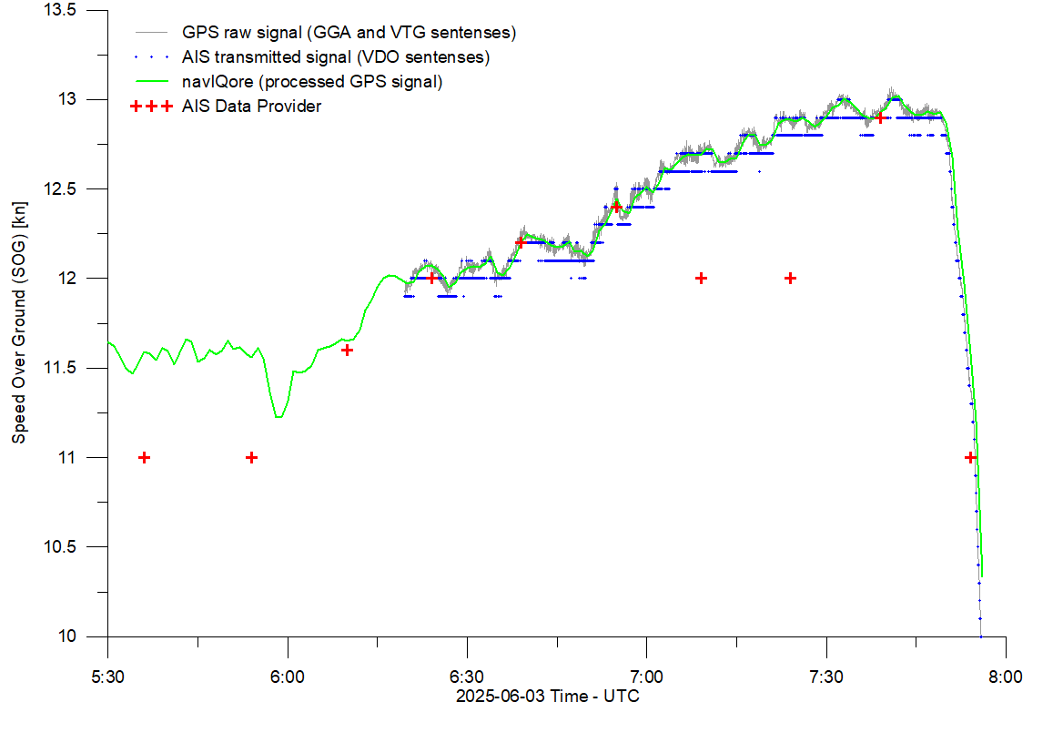
The investigation confirmed that navIQore's SOG values are a time-accurate, high-resolution representation of the vessel's actual motion, grounded directly in onboard GPS measurement, and that the discrepancy Mercury had noticed originated in the external AIS feed rather than in navIQore. For an operator relying on third-party AIS data for weather routing, the case is a useful reminder that external feeds can drift from ground truth in ways worth checking against a vessel's own high-frequency data — exactly the kind of validation navIQore's export and comparison tools are built to support.